Part 4 of a 6 Part Series
This is the fourth of a six-part series. The reader is strongly urged to visit these websites and study what is discussed in these articles in order to make an informed decision.
Part one covered data collection in the Comprehensive Wildlife Conservation Strategy (CWCS) which was used to create the State Wildlife Action Plan (SWAP) for species and habitat protection. In part two ecosystems and its components were covered and corridors were explained in part three. Now it is time to put all of it together with connectivity, the true agenda.
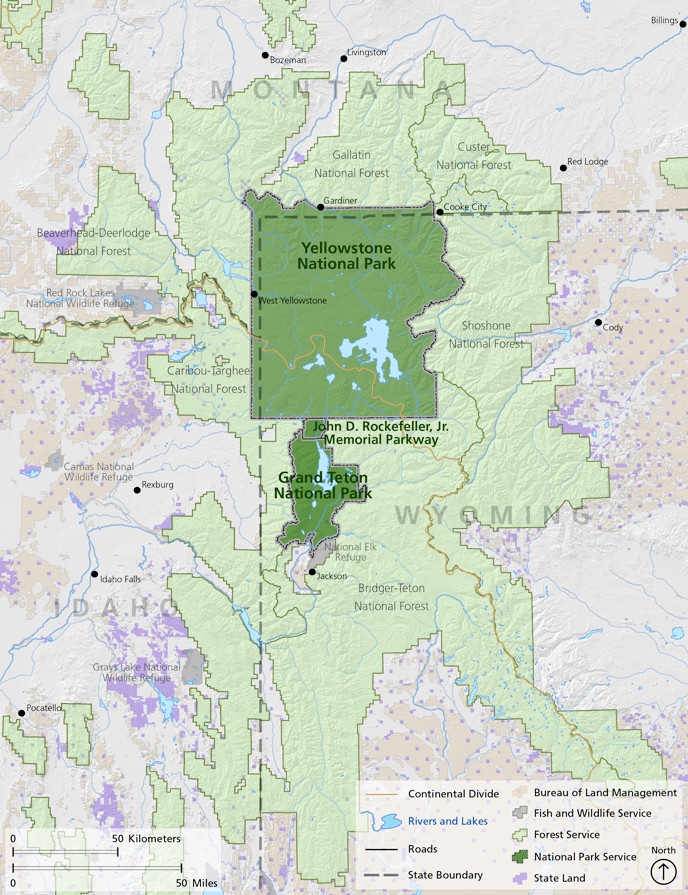
Here is the map of the boundaries in the Greater Yellowstone Ecosystem (GYE), where the corridors and components lay.
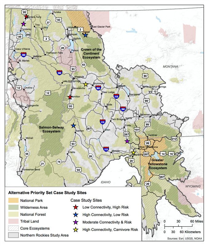
Keeping corridors within the ecosystem boundary is the foundation for connectivity with Island Park as a prime target in the GYE. NGOs and scientists are using the US 20 Corridor and Elk migration to advance connectivity at Targhee Pass. It has nothing to do with saving Elk, the Elk are being used for emotional manipulation and a distraction. Several targeted areas for redesign have now been narrowed down to just the Targhee Pass, only because it is the closest site for connectivity. With the Strategic Wildlife Action Plan (SWAP) identification of Species of Greatest Conservation Need (SGCN) and priority habitat conservation, along with other corridors, the plan has been established for sequential, consecutive, and progressive steps towards connectivity in the GYE, giving wildlife “room to roam”. Island Park has a yellow star for high connectivity, this connectivity plan has been in the works for several years, and that is why she is being targeted.
Scientists and NGOs believe connectivity is needed for species population persistence, ensuring that one or many species can move freely throughout the landscape. Because they also believe humans cause connectivity “fragmentation” with land development, a highly aggressive effort is underway to convince land owners to place their land into conservation easements (CE), restrict or ban road use, restrict development and growth boundaries, buy land, and take advantage of road corridors for halting fragmentation. To these groups, connectivity means highly restricted human use to none at all. Corridors and connectivity are the means to control land use. Once land is in their possession, regardless of being a CE, protected or restricted area, or any other designation, control of that land will be dictated by the government, NGOs, and land trust groups.
If your county elected officials allow it, these groups will try and convince them to change land use planning in comprehensive plans, forcing you to comply with conservation measures on your property, reduce land use, and dictate or halt how you use your land. The Wildlife Conservation Society (WCS) has already “provided site-specific science in this region to aid Fremont County, Idaho to prepare a comprehensive growth and subdivision plan that considers the importance of protecting biodiversity and wildlife migration corridors.” The Northwest Property Owners Alliance (NWPOA) in northern Idaho has already been through it and can tell you what will happen if your county acquiesces. They experienced the same dynamics being used by the US 20 Corridor study team including failure to notify, misinformation, and domination by special interest groups. Their article on environmentalism really captures what Island Park is experiencing.
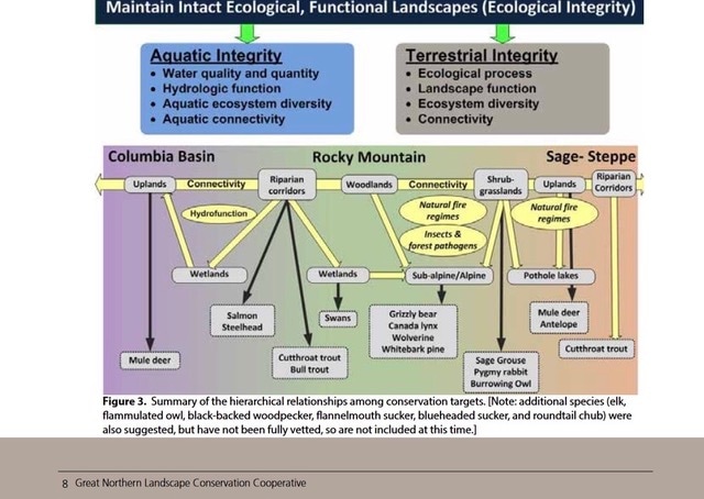
In 2015, after two years of steering committee meetings (including UN NGOs and Canada), the Greater Northern Landscape Cooperative (GNLCC) released a preliminary “Connectivity Pilot Project” report and “…selected connectivity as a priority shared landscape objective…”. The second of four objectives was to, “Conserve a permeable landscape with connectivity across aquatic and terrestrial ecosystems, including species movement, genetic connectivity, migration, dispersal, life history, and biophysical processes.” The corridors discussed in part three, plus the others listed here will all be used to justify placing Island Park into a massive, large scale, conservation area and eventual integration into the GYE as a protected area, under complete conservation status, with controlled land use. This agenda has been in the works for years, using Elk and the US 20 corridor is just the first step.
Their “data basin” is used to “inventory connectivity data”…”identify important areas for action”…”identify potential connectivity opportunities”…with the data also capturing…”‘human footprint’ layers”…”land use stressors that may be expected to impact connectivity”…”as well as map layers representing jurisdictional boundaries.”
Island Park is specifically targeted in this report. Using the High Divide (HD) as their “connection”, the short term objective included mitigating US 20 and Hwy 87 corridors and habitat augmentation at highway crossings. Long term objectives included annexing Henry’s Fork and Island Park from the Great Basin Landscape Conservation Cooperative (GBLCC) to GNLCC; supporting collaborative work of state and federal agencies, and NGOs to conserve private lands and connect public lands; focusing on landscape water conservation; implementing highway mitigation for key linkages; and creating disincentives for wildlife urban interface (WUI-zone of transition between unoccupied land and human development).
Participants in this report included Gary Tabor, Michael Whitfield, Gregg Servheen, and Renee Seidler, the new ITD road ecologist expert for the US 20 Corridor plan. Ms. Seidler has stated her belief in connectivity, her other work is on connectivity, the cooperative agreement between the ITD and IDFG states the job responsibilities included developing programmatic and site specific information and criteria on wildlife connectivity, and her job description states the same.
Conveniently, IDFG Wildlife Coordinator, Gregg Servheen, is on the GNLCC Steering Committee mentioned above, and signed the contract between IDFG and ITD for the position Ms. Seidler eventually took through the Wildlife Management Institute (WMI). Mr. Servheen also works on helping you turn your land over for conservation easements (CE) through the Private Landowner Network, or find conservation resources. He worked with the Western Governor’s Association (WGA) to build databases on biological information for preserving wildlife corridors and habitats, and the goal to “complete a connectivity/linkage plan” along the High Divide. While all of this gives the appearance of impropriety, it is nothing more than a self-created, conglomerate of government agencies and NGOs, operating under no legal authority, working without public involvement on plans to address issues they created, disguising it as their concern about wildlife vehicle collisions (WVC), and which will eventually be used as an excuse for wildlife connectivity. WVC are nothing more than a distraction to keep you from learning about the connectivity agenda. A copy of the contract can be downloaded here.
In fact, the ITD and IDFG were so confident the US 20 Corridor project was in the bag, they hired Ms. Seidler by April 17th to move on to the connectivity phase. This was at least 10 days prior to the canceled April 27th meeting that was supposed to include Island Park residents and their input.
Ms. Seidler is well prepared for this job having previously conducted a study with IDFG in 2014 called: US 20, Island Park Wildlife Collision Study, An examination of Road Ecology in the Island Park Caldera: Elk and Moose Migration Across US Highway 20. The summary states, “Conservation and mitigation efforts for Elk and Moose…will likely have significant positive impacts on habitat connectivity…”. A copy of this report can be downloaded here.
The GNLCC held a major workshop in 2015, Conservation of Continental Connectivity through Community Based Collaboration. Presenting at this workshop, the High Divide celebrated their increase in CE from 194,483 acres to 1.2 million in 9 years, and their work in connecting large core protected areas and wildlife connectivity. Their goal is Ecological linkage between protected core areas to conserve wide-‐ranging wildlife in response to climate change, not WVC. To them, “Working Across Boundaries” includes “Local expertise—stakeholder input”. This has rarely been sought from Island Park, but rather from an assembly of scientists, government officials, and NGOs, few who even have one connection to Island Park. The goal is complete “protected” connectivity in large landscape areas where Island Park sits. GNLCC held a Resource Managers Connectivity workshop in April, 2015, with Ms. Seidler as a participant and Gary Tabor and Michael Whitfield as speakers. Mr. Whitfield was also on the program committee for the 2014 National Workshop on Large Landscape Conservation held in Washington, D.C.. Federal government agencies and NGOs comprised 76% of the participants, with only 1% landowners participating.
As the founder of the Center for Large Landscape Conservation (CLLC), Gary Tabor has created both a Connectivity Conservation Hub in partnership with the GNLCC, located in Jackson, and a Ecological Connectivity Project with all the data and maps needed to conserve “a permable (sic) landscape with connectivity across its geography”. According to Mr. Tabor, “A corridor is a distinct component of the landscape that provides connectivity. Wildlife corridors specifically facilitate the movement of animals, while other types of corridors may support connectivity for plants or ecological processes.”
The Ecological Connectivity Project brings “managers” together who focus on connectivity. “The goal of the project is to conserve a permeable landscape with connectivity across aquatic and terrestrial ecosystems, including species movement, genetic connectivity, migration, dispersal, life history, and biophysical processes.” Michael Whitfield from the High Divide is also involved. This project does not include any Island Park residents, only government officials, NGOs, and initiative leaders. The justification for this project are primarily based on executive orders, policy resolutions, white papers, secretarial orders, and regulatory decisions that are not found in Idaho or federal law. However, GNLCC funding for 2017 is directed towards supporting this project for water, species, terrestrial and migration connectivity in large landscapes, your tax dollar.
Hidden on a US Geological Survey website is the 2015 proposal, “Landscape Conservation Design in the High Divide” with Mr. Whitfield as the Project Coordinator, and who is also the executive director of the Heart of the Rockies (HOR) initiative. Multiple NGOs, land trusts, and federal and state agencies are involved. The project summary “…seeks support to identify and evaluate future landscape configurations…emphasizing wildlife connectivity between large protected core areas…” such as Yellowstone. The need for “Landscape Conservation Design” was cited as one of the elements of the USFWS Strategic Habitat Conservation Plan. “A conservation design (cluster development) is a type of “Planned Unit Development” in which the underlying zoning and subdivision ordinances are modified to allow buildings (usually residences) to be grouped together on part of the site while permanently protecting the remainder of the site from development.” This project supports the GNLCC Strategic Conservation Framework, one goal being to “Conserve a permeable landscape with connectivity across aquatic and terrestrial ecosystems…”. All of the data collection will be used to redesign Island Park into some artificial utopian paradise, rather than let her exist as she has for centuries, or be developed through local representation. And with all due respect sir, do not lump residents into a “Human Modification Index. Workshops on this project were supposedly held in Nov 15′ through Fed 16′, conveniently when most residents were not available. This is how subversive these groups are. A copy of the proposal can be downloaded here.
These individuals and groups have been working with each other, making decisions about Island Park and the residents, behind their backs. Do those who live in Island Park want their covert plans?
The following initiatives and organizations are actively involved in the connectivity agenda: Heart of the Rockies (HOR); Yellowstone to Yukon (Y2Y), High Divide (HD), Crown of the Continent (COC), Greater Yellowstone Coalition (GYC), and Future West (FW).
“Although America’s national parks include some of the wildest places on Earth, no park in the U.S….is large enough to support the full range of native biological diversity over the long-term. In order to accommodate wide-ranging animals…our parks must be connected to other protected areas via wildlife corridors and their boundaries should be expanded wherever possible.” (Rewilding Our National Parks)
A brief word why so many “experts” are making the decisions. These scientists are actually technocrats, experts in science who have a lot of power in, or influence with the government and are an adherent of technocracy. Technocracy is the power shift from elected representatives and bureaucrats to technocrats (engineers, managers, scientists); management of society by technical experts; or a society that is controlled by scientists, engineers, and other experts. Is this not where we are at? Patrick Wood has a series of excellent videos on his website, Technocracy News and Trends, that provide valuable insight into how our government has transitioned over to these “experts” and away from the people. It is the responsibility of elected officials to listen to those who elected them, not technocrats or special interest groups, or those who are not Fremont county residents. Have we abdicated our inherent power and responsibility of self-governance to others? Or has it been stolen from us?
No efforts have been taken to disclose or involve Island Park residents in these plans, no alternatives to overpasses and fencing have been discussed, no input has been sought from anyone except the UN NGOs, cooperatives, technocrats, and government agencies, and No discussion has ever taken place on their plans for connectivity. Studies were conducted for the US 20 Corridor plan without required prior notification to Island Park residents. And why should they bother, the protection of Elk is not the issue, it is a distraction from what they are really planning.
All evidence points to the agenda for connectivity, on websites, in reports, participants own statements, and in studies. The ITD, their study team, NGOs, and initiatives have not been transparent with Island Park residents, misrepresented what they are actually doing, and have violated every drop of what is ethical. Shame on all of them.
It is important to remember, there is no federal legislation for this agenda. What law allows arbitrary erasure of jurisdictional boundaries? This is a concerted effort by individuals and groups with an ideology, who have successfully engaged the government with the same ideology, and are proceeding forward without any laws. Island Park has a population of 286 as of 2016. That swells to several thousand during the summer when residents come to their summer homes. The number of individuals pursuing this connectivity and conservation agenda are in the thousands, with millions of dollars being funneled into it. Island Park residents, who own homes and pay taxes, are the guardians of Island Park, and who elect city and country officials to represent them. Officials are obligated to listen to their voice, not special interest groups from other states or counties. The technocrats and elite who believe they know better, and who hide their agenda, are usurping those rights. Is this what Fremont County citizens want?
The Declaration of Independence states governments derive “…their just powers from the consent of the governed.” The Idaho Constitution, Article I, Section 2 states, “All political power is inherent in the people.” It is time to recapture the self governance our Founding Fathers created for us.
No individual wants Elk harmed and WVC must certainly be addressed. However, tearing up and environmentally engineering the land for ulterior motives is not the solution, there are other alternatives beyond what the technocrats say won’t work that require consideration. Island Park residents should be the lead in discussing these alternatives, how they want to protect her and the Elk, and the ones who hold the right to make those decisions.
Unlike my family, these technocrats and NGOs have zero connection to Island Park, spending their time reducing it to nothing more than a mathematical formula, and assigning point values for the purpose of artificially engineering it into something that it isn’t. There is no Island Park asset that has more or less value than another and in spite of what they say or believe, this land is not “fragmented” by us, it is fully connected in every way. They are welcome to visit and walk on the path they designated, but respectfully, do not come to Island Park for environmental engineering, passing it off as a transportation project for saving wildlife when your true goal is connectivity and “conservation design”. As her Guardians, Island Park is ours to protect, not yours to alter.
Part 5 will reveal where all of this originated.